New River George

In the fall of 2022 Cami and I headed out once again in search of fall colors and to check another park off the list. This time we headed south to New River Gorge National Park and Preserve. This National Park in West Virginia happens to be the newest National Park in the NPS system. Leaving for the trip I did not have very high expectations. East coast parks, particularly younger ones can be a disappointment when compared to the sprawling grandeur you can find out west. However, I was pleasantly surprised by this stunning and unique East Coast park. 

The park sits between Fayette and Summers counties in West Virginia. Covering an amazing 72,808 acres of pristine wilderness deep in the Appalachian Mountains. First established in 1978 as a National River by Jimmy Carter as he put it "for the purpose of conserving and interpreting outstanding natural, scenic, and historic values and objects in and around the New River Gorge and preserving as a free-flowing stream an important segment of the New River in West Virginia for the benefit and enjoyment of present and future generations."  New River was re-designated in 2020 as a National Park by President Trump. 

The New River has been a creative force to mold and shape the landscape of the Appalachian Plateau.  The area is a globally significant forest containing diverse flora; it provides essential habitat for endangered mammals, rare birds, and amphibians. The park contains habitats of continuous forest, cliff and rimrock, forest seeps and wetlands, mature bottomland forests, abandoned mine entrances. 

Humans have played a significant role in the New River areas in the 18th and 19th centuries. Evidence of their place in the land can be found throughout the park. The National Park services work hard to protect and even restore some of the abandoned places throughout the park while others are left to ruin. Throughout the park you can find evidence of the coal mines that once dominated the area including remains of historic coal mining structures and coke ovens. At one point there were over 50 company towns in the New River area. 

The railroad played a major part in New Rivers past and is still used as a major line today for the transportation of coal. There is no better example of this than the very well-preserved town of Thurmond. While inside the park the town is almost entirely owned by the National Park service. Except for the few residents who remain, and the rail lines still used by CSX today. 

The park does not have many roads that run through the interior of the park. You can drive around all four sides of the park and a few roads either let you cross from east to west or drive in to some degree and get to a trailhead. Since you have roads that circle the park you have a few choices of towns to stay in as well as several campgrounds both inside and outside of the park. 

We chose to stay in Beckley, a larger town with plenty of shopping and food choices. It was central enough for us, though some of our destinations proved to be a 1-to-2-hour drive. However, with a park this spread out and no central lodging that's going to be true for almost anywhere. 

Many people choose to stay in Fayetteville as its next to the park headquarters and the main attraction of the park itself. The New River Gorge Bridge completed in 1977 is one of the main attractions of the park. The bridge saves travelers over 40 minutes of driving time and spans one of America's oldest rivers. The bridge is the longest steel span in the western hemisphere and the third highest in the United States. It is one of the most photographed structures in West Virginia and is truly a work of art. 

Since 1980 the first Saturday in October has been known as “Bridge Day”. Hosted by the Fayette County Chamber of Commerce the park shuts down the bridge to motor traffic and allows pedestrians to walk the bridge and enjoy a wide variety of activities.  During Bridge Day visitors can enjoy great views, food, crafts, vendors, music and for a few Base jumping and rappelling from the bridge. Thousands of people from across the country come for this special day. This is also the only (as far as I know) National Park that allows some of the activities. 

We had around five days in the park and were lucky enough to be there just as the peak of foliage was starting. We explored most areas of the park; however we spent a very small amount of time around the bridge. That seems to be the most well attended attraction and we found a lot of beauty, and fewer people, in the rest of the park. 

We went twice to the town of Thurmond and got to explore almost all of it. It’s a wonderful place to walk through and spend time in. It’s amazing that there are even a few people left calling it home and living on the side of the mountain. You even get to drive over an old (but still active) rail bridge to get into the town.  Sadly, we did run out of time and did not get to explore the Red Ash Coke Ovens, likely the most popular other ruin attraction in the park. 

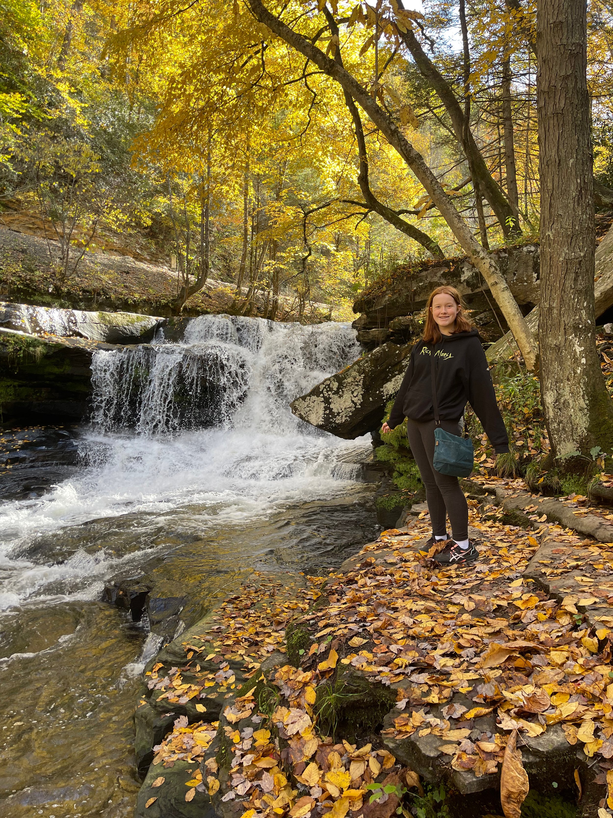
Some of my best memories and photos were taken along the way to Thurmond. The Dunloup Creek and Dunloup Creek Falls can be found along the road to Thurmond. They are well worth a stop and time to explore. Down in that valley was the peak of fall color and it was about as picturesque as the mountain forest can be. 

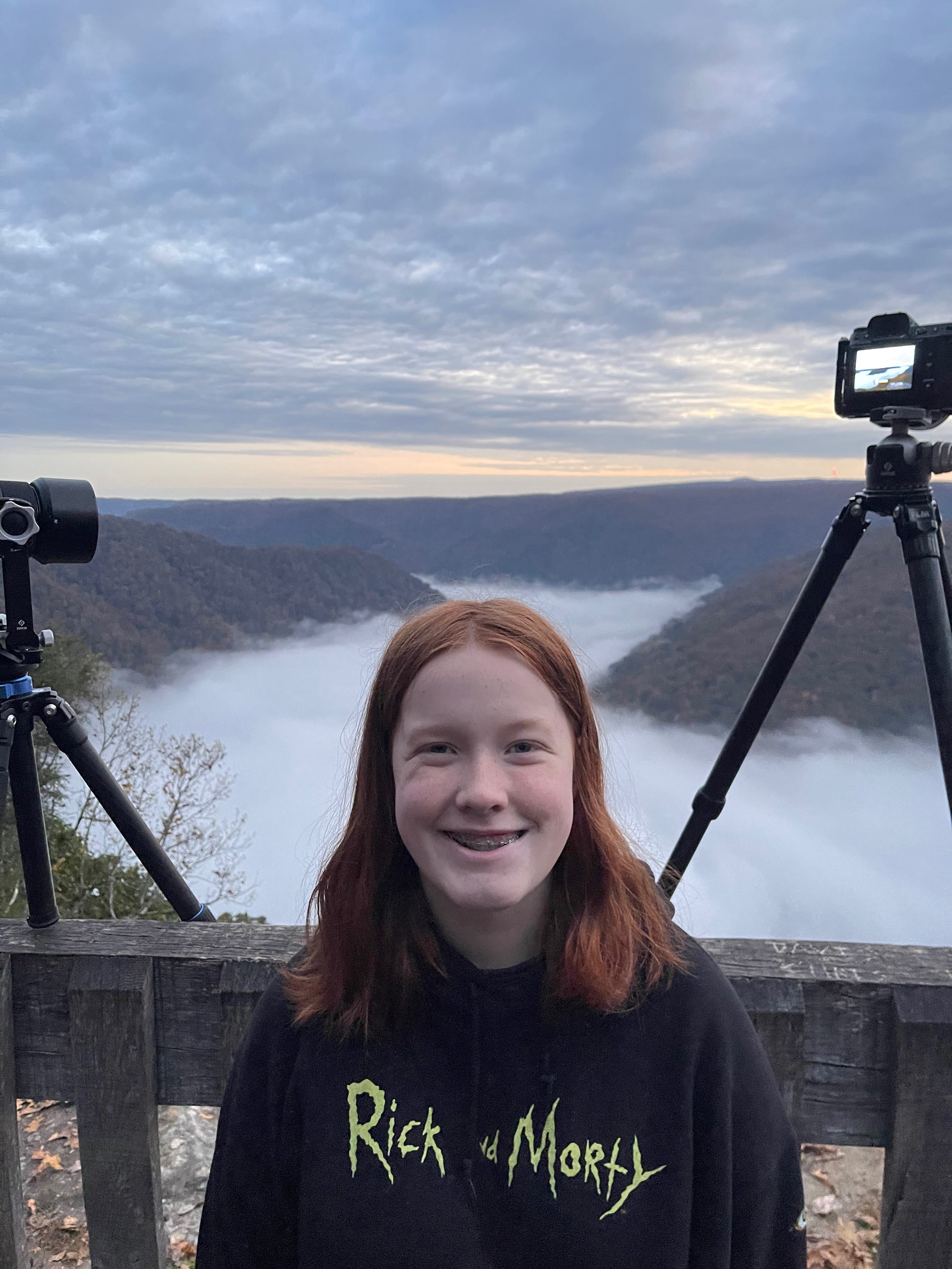
We spent two sunrises at the Grand View Overlook. This is the highest elevation in the park, you can walk out to the very edge at 1,400 and look down at a bend in the New River below. It’s the best overlook in the entire park (except if you're interested in the bridge). On the second morning there was a perfect cloud inversion and maybe the best sunrise of our entire trip. There are train tracks that run parallel to the river and the train lights would light up the clouds below us. After sunrise we explored some of the other trails that lead deep into the forest. 

We took the long and very scenic drive twice to Sand Stone falls. The drive there takes you to the park's only scenic riverside drive. You’ll pass a number of overlooks, historic sites, natural areas, trails and river access points.  You will pass through the lovely and historic town of Hinton. Once a booming rail center the town has a large historic district, railroad museum, shops and restaurants. 

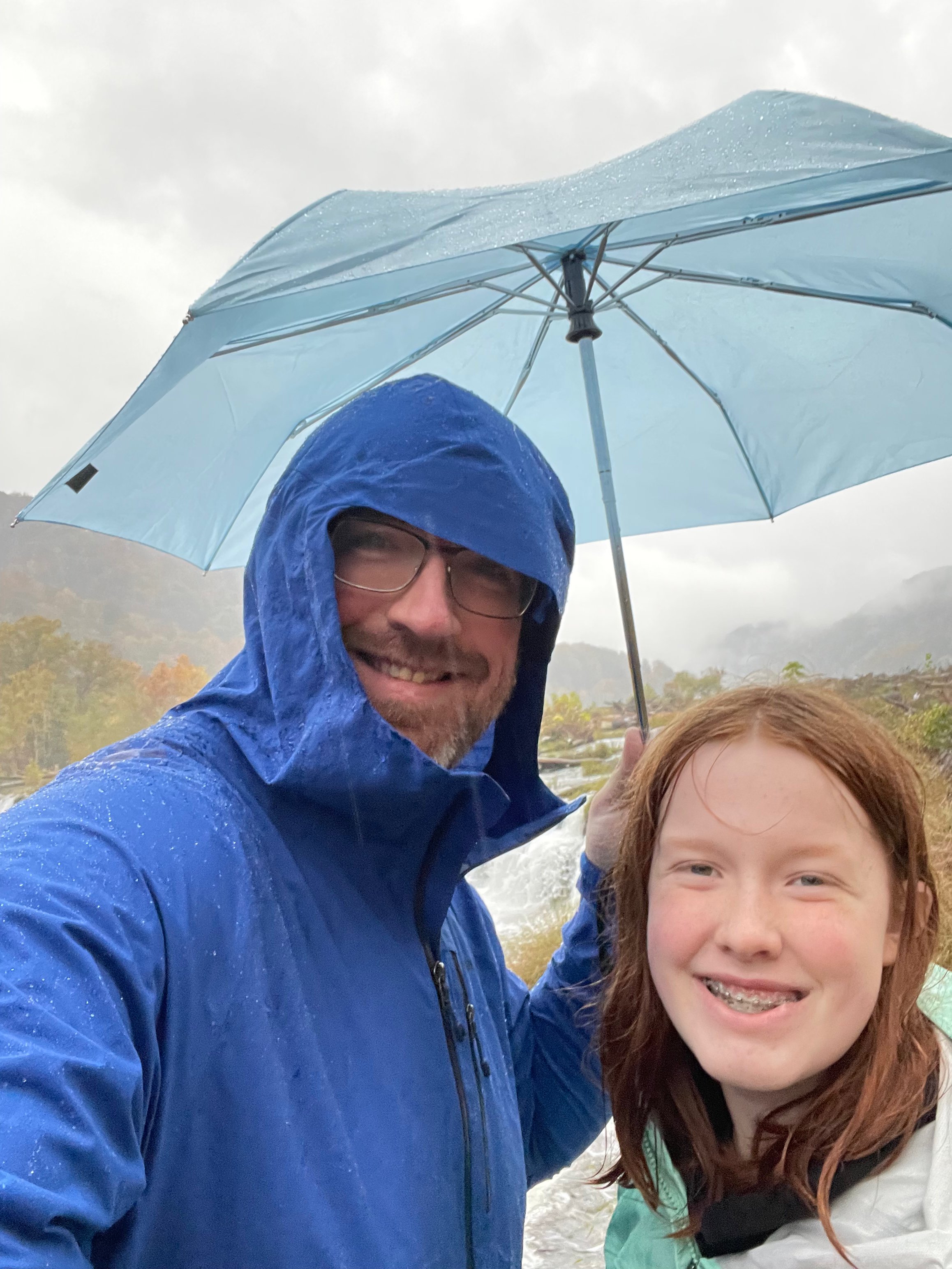
Sand Stone Falls is the largest waterfall in the New River. Here the river spans 1,500 feet wide and is divided by a series of island sand river drops offs 10 to 25 feet. There are a number of trails and ways to explore the area. The first sunset here was a clear day with only a few clouds but still stunning. The second sunset we spent here in the driving, pouring rain. I created one of my best images that afternoon. It goes to show that sometimes the worst conditions can yield the best results. 

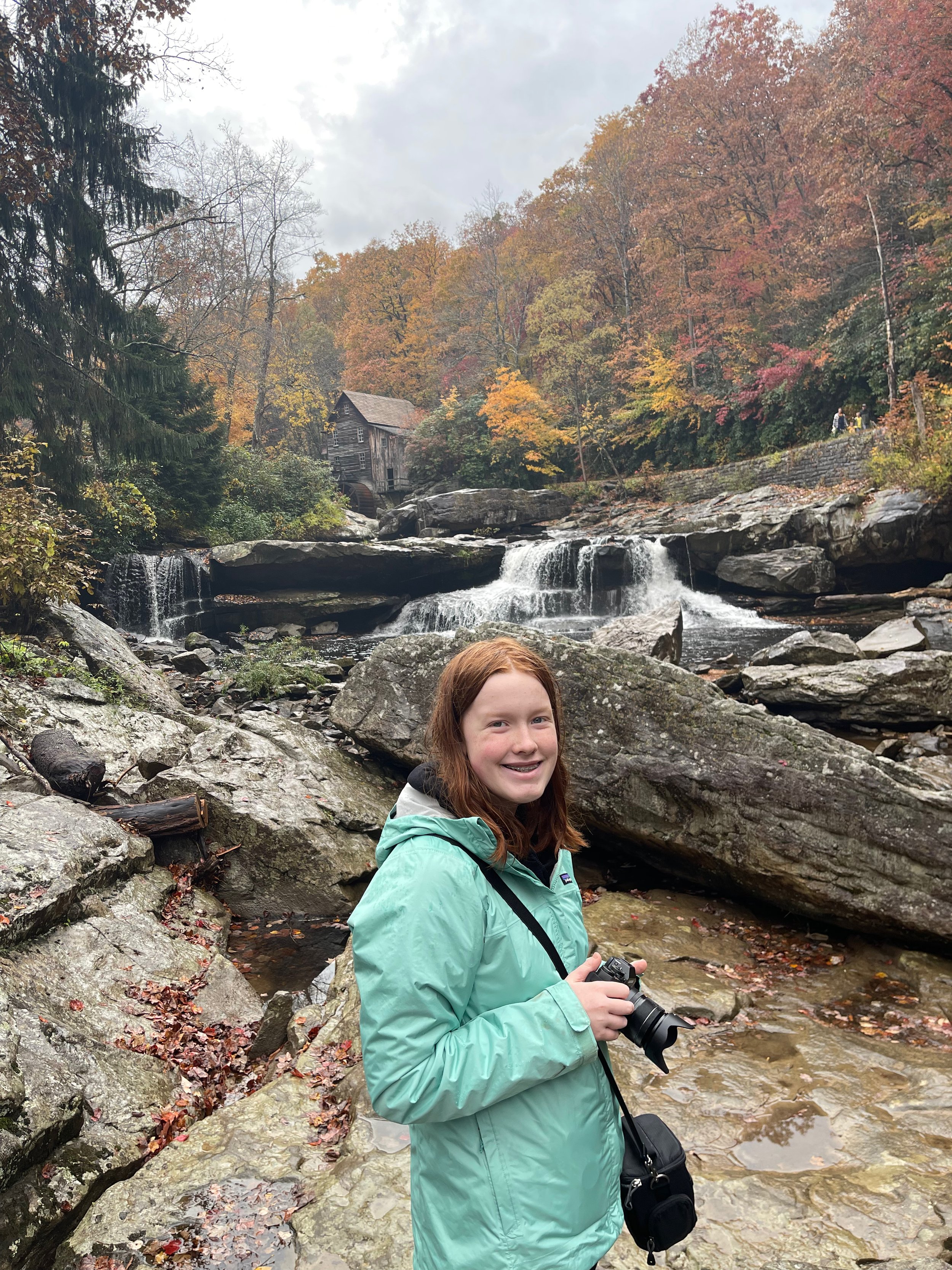
The other long drive we made was not to a destination inside the park but rather to a local state park. Babcock State Park with its 4,127 stunning acres is worth a stop to anyone in the area. The main attraction here is the Glade Creek Grist Mill. We first checked out the visitors center then made our way down to the river. Again, in the pouring rain to photograph the mill from the middle of the river. After we were thoroughly drenched, and I had a photo we made our way to check out the mill itself. The grist mill is still fully functioning and if your there on a lucky day may even be running. 

Overall, it was a great visit and the right time of year to the new member in our National Park family. Maybe most surprising of all is that I’m looking forward to finding a time to return to the area.

Chris Blake
Hawaii

In August of 2022 our family took an epic two week trip to Hawaii. This would serve as both our yearly summer vacation as well as a chance for Cami and I to check off two National Parks.  Hawaii is not next door to our home outside of Boston so we wanted to do as many ‘notable’ things as possible. 

We started our journey flying from Boston to Honolulu and after a short a layover to our first stop onto Hilo at the big island. Fun fact, the 12 hour flight from Boston to Honolulu is the longest flight you can do between any two points and still be in the United States. Both of my children are champs and great travelers and we had no issues making the long trek.

For the Big Island we flew into Hilo and made the ~45min drive to our airbnb way up on the mountain near Volcanoes National Park.  Most people who visit the Big Island fly to the other side at Kona and stay in one of the many resorts there. Our focus for this island and really our trip was on the parks and nature. We avoided many of the more developed areas of this (and the other) islands. 

The AirBnb we found was truly stunning, sitting just 10 minutes from the entrance to the park and surrounded by nature located in the historic Volcanoes Village. The story that we heard was that our house was originally the plantation manager's mountain cottage. A place for him and his family to escape the heat (and work) and relax. During the evenings we had temperatures in the 60/50s and I don’t think we could have found a nicer play to stay. If there was a downside it was that everything, other than the park, was a far drive. Beaches, stores, waterfalls, the other mountains all required a minimum of an hour drive each way. 

Hawaii Volcanoes National park encompasses two active volcanoes, Kilauea one of the most active in the world and Mauna Loa the world's most massive shield volcano.  The park was first established in 1916 as Hawaii National Park, later split into Volcanoes and Haleakala National Park in Maui.  The park encompasses a massive 323,431 acres and half the park is designated as Hawaii Volcanoes Wilderness area.  The park spans from the sea all the way to the peaks of the volcanoes and protects a diverse environment. 

The park has been home to volcano activity throughout its history. The most recent eruption was in 2018 forcing the closures of the Kilauea volcano summit area including the visitors center and park headquarters due to explosions and toxic ash clouds from Halema’uma’u. Some of the park's roads and accesses are still closed to this day. 

Kilauea and the Halema’uma’u caldera are traditionally considered the sacred home of the volcano goddess Pele. In 1790 a violent eruption occurred killing a party of warriors along with women and children who were in the area. Their footprints in the hardened lava are still visible to this day. 

We spent the bulk of our time exploring the National Park. We spent two sunrises at the Kilauea Overlook. It was a very short drive from our house in Volcano Villages and if you get there very early you can see the glow of the lava in the crater. It’s a really peaceful place and a wonderful spot to enjoy a sunrise. 

We spent a lot of time on the Chain of the Craters Road. It’s a super fun drive and has a ton of very interesting places along the way to stop and explore.  The Pu’upuai Overlook is a very different view than you get from Kilauea Overlook and very much worth a stop. Sadly the Lava Tubes were closed due to earthquakes and unstable rocks. We did a few of the hikes along the road that were very interesting with a surprisingly diverse landscape.  There are also a number of smaller craters along the road to explore. 

After a while driving down the road the jungle sort of stops and you find yourself in lava fields for as far as you can see.  There are a number of lookouts that start to give you ocean views. After those you go through a series of switchbacks all the way down to sea level.  Right before you reach the ocean are the Pu'u Loa Petroglyphs. We did the short 30 min hike and it was a great time for the family. 

If you continue down to the ocean you can stop along the way for a number of great views of ocean cliffs and watch the waves crash into the island. At the end of the road it’s a short walk to the Holei Sea Arch. This road proved to be wonderful for both photographing and exploration. We had a ton of fun exploring all of it. 

Since our AirBnB was rather remote and there were few choices of restaurants in our area we made most of our meals at home. With two notable exceptions, my wife found a taco truck that was only open one of the days and it was amazing. If you are ever in the Volcano Village area you should check out Rico’s Tacos, we wished they were open more days. The second was Ken’s House of Pancakes, where we had a number of meals. This place seems like a fixture of Hilo and was well worth the drive. 

We did explore a bit more of the island. Including a number of the waterfalls around the Hilo area. Twice we drove to the far side of the island to the much more populated Kona area. We hit a few of the beaches including Kailua Beach in the Old Kona Airport Recreation Site. This site was harder on the feet as the beaches were mostly lava rock both in the water and along the shore. Many of the beaches we tried to go to were state parks and they unfortunately closed and gated off the access roads well before sunset. There was the option to hike in but it would have been a far walk back in the dark for the kids.  I took full advantage of the west side of the island and would stay and photograph sunset.  

We also made the drive to the top of Mauna Kea. A volcano with a peak of 13,803 feet and home to the world's largest astronomical observatory and 13 working telescopes. If you have the chance it’s well worth the drive to the top. The views are out of this world. 

After our time in the Big Island we headed to Maui, though we had to take a little detour as we missed our direct flight. However lucky for us Hawaii Airlines flies almost every hour (or less) between most of the islands and Honolulu. So it’s rather easy to catch a later flight and find your way to whatever island you are looking for. 

In Maui we once again chose to stay away from the more populated and touristy areas and found a great AirBnb in Kula. The property was surrounded by farms and ranches and had a view of the volcano. However, unlike the big island it was much closer to shops and restaurants so it made life a bit easier for us. 

The main attraction for us at least was Haleakalā National Park and all the wunder it had to offer. The park derives its name from the dormant volcano Haleakalā. The park spans an impressive 33,265 acres or 52 sq miles. The park was first protected along with Hawaii Volcanoes National Park in 1916. It was separated into its own national park in 1961. The area is also designated as an International Biosphere Reserve. The park is split into two sections; the very popular summit area and the coastal Kipahulu area past the town of Hana. 

Haleakalā has an incredibly diverse climate. Starting with a  tropical rainforest near sea level and then into a tropical monsoon climate. As the altitude progresses the climate becomes oceanic to Mediterranean, reaching, at the very top of Haleakalā, an alpine climate. All of this in one park, in one drive, it’s truly incredible.

At the summit you will find a visitors center and also the Haleakalā Observatory. The summit lies above the cloud inversion so the sky is almost always clear. This is a wonderful dark place if you're into stargazing. If you come here before / after the moon is up or on a new moon you will see a sky full of stars. 

Sunrise at the top of Haleakalā volcano is the main attraction here and something we had to do (twice). The top of the mountain is just over 10k feet from sea level. To get to the summit you must travel a 37 mile winding road. We were fortunate that our AirBnb was close to the start of the road. You want to get to the gate of the park a few hours before sunrise, to give yourself an hour to get up and early enough to find a good spot. Those who stay in town have to leave an hour or two earlier just to get to the base of the volcano. 

They ‘limit’ (more on this in a second) how many people can come for sunrise. You have to have a reservation through recreation.gov. The cost is only a dollar and the idea is to stop overcrowding at the summit. On the first sunrise Cami and I were the first in the parking lot, however only moments after cars started to stream in. We had visited the summit the day before and I knew exactly where I wanted to set up. We made the short walk to a spot that is at the very edge of the crater and sheltered by the visitors center. In my opinion this was the very best view for sunrise. More and more people started to jockey for a spot at the rim, and then tour buses started to show up. By the time the sun came up the place was jammed with people. While the experience was truly stunning the massive crowds took a bit away from it. I will say the native Hawaiian tribe that sings every morning was extremely special. 

For our second sunrise adventure at the top I chose the parking lot you come to before the summit. After a short hike you can have an equally stunning view with almost no people. I think by the time the sun rose above the clouds below us there were only 10 people there. 

If you're in Hawaii get tickets, get up super early and go here to watch the sunrise. The clouds are almost always below you, you can see out to the ocean and other islands. It’s maybe the best sunrise location I’ve ever seen. 

If you're not a sunrise type person you can always stop along the winding road on the way down and watch the sunset. That is what we did on our first night, and it was equally spectacular.

Many people had warned me about the drive ahead. There is a belief the drive is very hard and scary. The road is long and winding, gaining just shy of 10k feet of vertical elevation, and with some grades over 15%. The road is well maintained but without guardrails. There are some rather steep drop offs, blind turns, etc. However, if you take it easy you should be fine. I had a blast driving up and down the volcano road in fact. If heights are not your jam then there are the tour buses (as I talked about above) who will take you from the hotels all the way to the top. Since the hotels are so far away you do have to get up very early for the buses. 

The Kipahulu section of the park is not connected to the summit section by any roads. The only way to get there is to take the windy mountain Road to Hana. Once there you find two main attractions: the two dozen pools along Palikea Stream in the gulch called ʻOheʻo and the Waimoku Falls. Much of the remaining area is  closed to the public as it is designated the Kipahulu Valley Biological Reserve. This area is set aside to preserve the fragile ecosystem. 

We spent an entire day taking the Road to Hana and I will say that it is the most incredible road we have ever had the pleasure to drive. The road is only 52 miles long however, the very windy, narrow road passes over 59 bridges, of which 46 are only one lane wide. There are approximately 620 curves along the road. Most of the one lane bridges and concrete work date back to 1910. 

The best part about the drive is all the places to stop and explore. The entire drive is in a rainforest, going up and down mountains and following the coast line. There are many waterfalls and other attractions. There is however very limited legal parking, and the trick is to find a place to stop and not get ticketed. Even in our short time at one of the popular locations we saw police come and ticket almost 20 cars. 

After driving through Hana you arrive back in the National Park. We did the waterfall hike up the mountain. Well Cami and I did the entire hike, Cat and my son Collin only made it to the first waterfall before heading back. I can’t really blame him, the entire hike is uphill. The bamboo forest near the top of the mountain was maybe my favorite part of the hike. 

On the way back we found a roadside stand selling burgers with all locally raised meat. It was a really great way of ending the day.  Driving the road to Hana in the dark is something everyone tells you to avoid. However, for us I think this worked in our favor. During the day the road was packed with cars and very slow going. At night without many cars the drive is much faster. Though you still have to slow down for the one way, 240 degree blind turns around a mountain with a thousand foot drop off to one side. 

When not exploring and hiking we spent some time on the various beaches of Maui. The first day we took the kids snorkeling at Olowalu. As you’re driving up the coast on Route 30 look for mile marker 14. There is plenty of parking under the trees and off the road. There are over 400 acres of coral off the beach and the waters are relatively calm which makes it a great spot for families with kids. The coral here is estimated to be over 500 years old and we saw some of the most amazing fish including the humuhumunukunukuāpuaʻa, the state fish of Hawaii. We also hung out at the first Kamaole beach (1 of 3). There wasn’t any coral where we were but we still got to see some fish, and several sea turtles swam right by us which was Cat’s biggest wish. 

We again in Maui made many of our meals in our AirBnb. However, just down the road in the closest shopping plaza we found a food truck area. We went there for lunch a number of times, and they had amazing options and it was all really good. 

After our time on Maui we flew to Honolulu where we would spend our last two days in Hawaii. Since we spent all our time on the first two islands far removed from civilization we did a 180 and stayed in the middle of Waikiki. 

The only major activity we did over the two days was to head over to the Pearl Harbor Memorial. We spent a good afternoon there, and managed to get tickets to go see the Arizona Memorial. This is maybe one of the best run, setup, and saddest of all the National Monuments. An incredible amount of effort was put into making this place a true lesson in history and a wonderful learning experience. 

A quick note if you're heading out this way, going to the Arizona is almost a must in my mind. You have to buy tickets well in advance and they sell out very quickly. We had no luck buying them when they first came on sale. They released a few the day before and we were able through sheer luck to pick them up. Oftentimes the hotels and tour groups try to buy up all the last minute tickets and sell you very expensive tours that include Pearl Harbor and the Arizona.  I was happy to not have to pay that penalty. 

Other than going to Pearl Harbor we spent a good amount of time walking around Waikiki. We enjoyed our hotel pool, local shopping and dining. It was a wonderful way to end our Hawaii trip. 

We did have a bit of an adventure getting home. Our first play was delayed, after we boarded late, they found mechanical issues with the plane. We had to change planes and we landed in LAX very late. This made us miss our connection home, but with some luck and fantastic service from JetBlue we were able to get on a later flight and made our way home. 

All and all Hawaii was a 10 out of 10 experience for the entire family. 


Chris Blake
Theodore Roosevelt National Park Second Trip 2022

Our trip in 2019 to the Badlands National Park in South Dakota was supposed to include a trip to Wind Cave National Park. Sadly, for us on our flight out west we learned that the elevators had broken and there would be no tours. It took the park over a year to get the parts and fix the elevators. 

My wife had very much wanted to see Wind Caves as well as Theodore Roosevelt National Park. Since the elevators had been operational for almost a year, we thought it was safe to make another attempt. 

The plan was to fly out west, spend a few days in Teddy and spend a day or two at Wind Caves NP.  While enjoying maybe the best sunset of the trip in the North Unit of Theodore my wife got the dreaded phone call from Wind Caves. Letting us know that once again their elevators had broken down and all tours would be canceled. 

Due to the untimely and unfortunate closure of the caves we spent four days exploring, hiking, and photographing Theodore Roosevelt National Park. For both Cami and I this was our second time here (you can read more about the park during our first visit here), for my wife this was her first time. 

We stayed (once again) in Dickinson ND, this is not the most convenient place to stay as it is nearly a 40 minute drive into the park. You can stay right outside the South Unit of the park; however, the lodging and food options are much better in Dickinson. Since we had enough time, we saw almost all the park. Did many of the hikes and trails. We saw all the wildlife, Buffalo, wild horses, prairie dogs, deer, and elk. Cat was particularly thrilled to see the Bison as there weren’t many when we visited the Badlands in 2019 and the herds in both the North and South Units had babies. It was also thrilling to get to see the wild horses running through the park. 

The weather for our trip was a little bit all over the place. For the first two days we had temperatures in the mid 90s, then all the sudden the highs were in the 50s with lows in the 40s.  It also became very windy for the last two days making the low temperatures feel even colder. 

Though cold and stormy, the weather sure did make the landscape even more beautiful.  On our third day in the park, we headed up to the North Unit (again) in the mid-afternoon. The sky was full of storm clouds, it was cold, and the wind was whipping. It’s an hour and a half drive from one end of the park to the other, and while we were approaching the North Unit it started to rain, and then pour. The rain made all the greens of the landscape “pop” even more, and the storm clouds above made for a spectacular view. While the rain was slowing down, I photographed the “cannonball rock” area. These might be some of the most unique photos from either of my times in the park. Cat and Cami wandered off up into the rocks and discovered some cacti and wildflowers to photograph.

While waiting for sunset one of our last nights in the southern unit of the park we spent some time in Medore, the town directly outside the entrance to Teddy. There we had some fantastic homemade ice cream and then went on to check out Teddy’s Bears. The teddy bear was named in honor of Theodore Roosevelt after he refused to shoot a treed black bear during a hunt as he viewed it as unsportsmanlike. A maker of stuffed animals in Brooklyn, NY saw the article on the event and, after receiving permission of Teddy himself for the use of his name, created the Teddy Bear we all know and cuddle today. Teddy’s Bears sells a wide variety of teddy bears but the two we purchased were both dressed in honor of Theodore Roosevelt’s time in the park area, the Rough Rider Teddy Bear and the Badlands Teddy Bear.

It was a great experience to see the park for the second time. I had already captured an amazing photo from there on our first trip, so I did not feel the usual pressure to create something new. I think that allowed me to see more of the park in a different light. While I’m still editing the photos, I’m hopeful that my time there will produce some truly unique and interesting photos.

We left the park and drove the eight hours back to Minneapolis as our flight was at 10am the next morning. We checked into our hotel in the University district which was an amazing place to stay. We dropped our stuff in the room and headed down the front desk to ask for restaurant recommendations. They suggested a few places nearby and we ended up at the Surly Brewing Co. This place was a fantastic find though what we weren't aware of is that the food comes out as it is ready. So even though we thought we had ordered appetizers, the items we had ordered as sides for our main dishes came out first. It didn’t matter, the food was all amazing and the choices for beer were endless. 


Chris Blake
Indiana Dues and Chicago

Our next adventure brought us to Indiana Dunes National Park and the city of Chicago in the early springtime.  Cameron and I headed from Boston to Chicago and then made the short drive to Indiana Dunes. After our time there was finished, we met up with Cat and Collin in Chicago and had a wonderful weekend exploring the city. 

Indiana Dues in northwestern Indiana was first established as Indiana Dunes National Lakeshore in 1966. It was ‘upgraded’ to full park status in February of 2019. The park has around 20 miles of coastline along Lake Michigan. At only 15,349 acres it’s not a very large park but it is easily accessible. 

The area around the park is almost fully developed with both residential, commercial, and even heavy industry. On the east end of the park there is even a steel plant that interrupts the park's lakeshore, and on the far other end there is a massive coal plant where a massive dune once stood. It makes for a very different park experience, much different than those surrounded by wilderness. 

Efforts to save this area started all the way back in 1899, when a movement began to preserve the dunes habitat. The sand was being trucked off to manufacture glass in such large quantities that many of the original largest dunes were lost.  In 1926 the Indiana Dunes State Park was opened to the public. In the 1950s the “save the Dunes Council” was formed to prevent further development of the lakefront and dune area.  In 1966 a bill passed congress and the Indiana Dunes National Lakeshore was created. The park has been expanded four times in subsequent years.

We stayed in the small town of Chesterton, which was a short 15-minute drive north to the park. The area was full of restaurants and all the shops you could want. Getting into and out of the park was easy, it's a long and narrow area and easily accessible. We went in the early spring, when it was still much too cold to swim in Lake Michigan. This was to beat the crowds of people that come to the lake every summer. For the most part we had the park all to ourselves. 

We spent three days exploring the area, hiking the dunes and walking around the marshes. On a clear day from the beach, you can get a nice view of the Chicago skyline. The most interesting area might have been Mount Baldy. A massive 123-foot-tall dune. It is a wandering dune that is moving an average of 4 feet per year. You can’t hike the dune itself but there are trails all around the dune to explore. Cameron has had a passion for finding sea glass for as long as I can remember. She was thrilled to discover beach glass within the park. Honestly it was likely her favorite part of this entire park!

Sadly, this may have been the least interesting park we have visited or maybe it ties with the Arch in St. Louis. In the summer the beaches create a wonderful area for locals to enjoy the beaches and water. 

After our short time in the Dunes, we made the two-hour drive back to downtown Chicago, dropped off our bags and got some deep-dish pizza and then had an amazing time photographing a stunning sunset of the Chicago Skyline. The day was full of storms, and they stopped and broke just long enough to give us a crazy wonderful sky. After that we headed up to the airport to pick up Cat and Collin.

We used the City Pass to hit up all the major attractions in the city. Since everyone got in so late the first night was rather low key.  The next day we started early and got into the Museum of Science and Industry just as they were opening. If you have never been here this is a can't miss stop, it's truthfully one of the most interesting places we have ever visited.

After the Science and Industry museum we headed over to the Shedd Aquarium and spent a few hours walking around there. After that we headed to the Skydeck Chicago, the top floor of the Willis Tower (Sears Tower). There are other sky decks in the city but there is something so cool about the top of the old Sears tower. Afterwards, we went to one of my favorite places to eat, The Weber Grill.

Our last day in the city we started at the Field Museum, and we saw four of the main exhibits but sadly ran short on time. You could spend an entire day walking around the Field Museum. From there it’s just a short walk up to the Adler Planetarium where we had lunch and watched one of their shows.

If you have never used it before, the City Pass really is a great way of finding and seeing all the major attractions a city has to offer. Oftentimes there are some good savings on entry as well as dedicated entry lines that can save you a ton of time.

Chicago is a city that needs more time and I look forward to dragging my entire family back out there soon. 

Chris Blake
Gateway Arch & Mammoth Caves National Parks

In February Cameron and I were back on the road to knock off two more National Parks. First, we went to St Louis to visit the small and strange Gateway Arch National Park, after that we made the drive to Kentucky to check out Mammoth Caves National Park. 

 If I’m honest we have long avoided the trip to St Louis, the Gateway Arch does not really seem to fit in well with the rest of the National Parks. As a physical structure that is in-itself truly a monument, that maybe it would be better categorized as a “National Monument”, I digress. 

 I chose to visit the park in winter for a few reasons. First, I wanted to avoid any crowds of people (for photos and for tours), second, I was truly hoping it would snow (and it sort of did).  The nice part about timing our trip was that the city was empty, the hotel rooms were cheap, and we never had to wait for a table to eat in any of the fine BBQ places we came across. 

Gateway Arch National Park is a relatively new park, ‘upgraded’ to full park status in 2018, the park covers a very small 90.9 acres of land.  The Arch is located on the banks of the Mississippi River, near where the Lewis and Clark Expedition departed.

The Arch is a monument to several different events in our history. Most know it as a symbol of the westward expansion of American pioneers, but also to the Louisiana Purchase, the first civil government west of the Mississippi River and the Dred Scott case over slavery. 

The area was initially designated the Jefferson National Expansion Memorial all the way back in 1935. Other than the Arch the park also hosts the Old Courthouse where the Dred Scott case originated, a massive 140,000sq ft museum, and several walking trails. 

The Arch is thest e tallstructure in Mississippi at 630 feet. Designed by Finnish American architect Eero Saarinen in 1947, construction started in 1963 and completed in October 1965.  The legs are a massive 54 feet wide and narrow to 17 feet at the top. 

We had three days to explore the Arch and St Louis. We stayed at The Westin St. Louis, right across the street from Busch Stadium and an easy walk to the Arch. Being it was the off season the hotel was rather empty (and affordable), and I can’t recommend it strongly enough. 

Compared to other parks there is not a huge variety of activities you can do. However, on the first day we headed into the park and visited the Museum. It’s massive and sits directly under the Arch itself.  There are exhibits on a variety of topics but mostly focused on western expansion and the arch itself. As National Parks go, this Museum is at the top of the list. 

That same first day I had purchased tickets to take the ride to the top of the arch, to the tiny observation deck. The tram system is an engineering wonder all by itself.  The ride to the top of the arch takes place in a white egg-shaped pod or capsule, each pod is connected to seven others and makes up the train. This is what 1960s engineers imagined the future would look like. 

Each pod in the train has five chairs and is a total of five feet in diameter. This train and pod system is a mix between an elevator and Ferris wheel.  The ride takes four min to get to the top, and the door is made partly of glass, so you get an incredible view of the inside of the arch. 

The view from the observation deck at the top is simply stunning. You can see in all directions for what would seem to be endless miles. If you're ever in the area it's truly worth checking out and making the trip through the museum and up to the top of the Arch. 

We spent the other days going back and checking out the museum, exploring the area around the arch and of course taking some photos. It was cold and we did get a dusting of snow but not the real accumulation I was hoping for.  We also ventured over the Mississippi to the Illinois side to check out Malcolm W. Martin Memorial Park. There is an observation deck there with some nice views of the city and the Arch. If I had more time I would have tried to explore more up and down the river to find a more interesting photo location. If you do go here, please keep in mind this is East St. Louis is known for being a dangerous area. We had the place to ourselves on the cold winter night.

We also had some very fine BBQ while in St. Louis. I think our favorite was Salt + Smoke right across from the baseball park and down the road from our hotel. It’s definitely on our list of places to eat at again if we find ourselves in the area. 

After a few days in St Louis, we headed towards Kentucky and Mammoth Caves. While we did not have very high expectations for either of these parks, we were pleasantly surprised with the caves and had an amazing visit. 

Mammoth Cave National Park was established in 1941 and is the largest cave system known in the world. As well as being a National park it's also a World Heritage Site and an international Biosphere Reserve. There are 420 miles of surveyed passageways making it nearly twice as long as the second-longest cave systems in the world. No one knows how large the cave system is, it’s yet to be discovered.

There is a truly ancient and amazing history that belongs to these deep caves.  There is evidence that humans have inhabited these caves for over five thousand years. Several sets of Native American remains have been recovered from Mammoth Caves. The unique climate of the caves helped preserve and mummify those who were buried here. Evidence can still be found today of their time in the caves. 

Legend has it that the first European to visit Mammoth Cave was either John Houchin or his brother Francis Houchin around 1797. There is some debate and mystery as to who first discovered the cave.  In 17989 the land containing what we now call the “historic entrance” was surveyed and registered by Valentine Simons. Simons started to explore the caves for its saltpeter reserves. 

Mammoth Caves was very much a ‘working mine’ and through the War of 1812 provided saltpeter to the Nation. This was critical as all foreign trade was banned by the Jefferson Embargo Act of 1807, and thus the US was unable to produce gunpowder.  As the war ended and demand for saltpeter faded, mining ceased. There is a fascinating history on ownership to different areas of the caves that is much too detailed to get into here; however, if you are interested, I’d encourage you to read more about it. 

After mining ceased to be profitable the caves turned into a tourist attraction. As tourism became the main use of the Cave this led to the “Kentucky Cave Wars” in the early 20th century. This Is a long period of time where bitter competition between local cave owners took place. Many tactics were deployed to win over tourists, many today we could consider less than ethical or even legal. This is also the period where many of the man-made entrances that we enjoy today were created. 

One such man was George Morrison, who came to south central Kentucky first to look for oil but soon after became interested in the caverns. He acquired 2,000 acres of land and at the base of a large sink hole he blasted an entrance into the cave. Soon after he built a set of wooden stairs (that have since been replaced) and started to offer tours. Morrison’s entrance leads to one of the most famous attractions in what is known as the “frozen Niagara, due to the grandiose flowstone formation that appears when the water freezes. 

Morrison was not alone in the quest to profit from offering tours in the area. The writing on the cave walls as well as rock towers built are reminders of the early tour groups in the caves.

The fractured ownership of the caves was causing issues, and as early as 1926 there was a movement to unify the cave owners and convert it into a national park. Through a process of donations, buyouts and eminent domain the state was able to transfer the land to the Federal Government. In 1941 the Caves were established as a National Park after the Civil Conservation Corps had done amazing work clearing the land above and creating paths and trails in the caves themselves. 

We had three days to explore this strange and amazing place. We signed up for four different ranger led tours. Each of these would explore different areas of the cave and use different entrances. Each ranger did an amazing job telling the story of that area of the cave system and made for a wonderful experience. However, it was very limiting for photography. I will go back with a special use permit so I can spend much more time in the caves. 

 What struck us the most is that each tour is very different, the cave system is so huge that if you took two different tours it would be hard to believe they are the same cave. Some have grand rooms; others narrow tight water formed tubes. We enjoyed the Historic Tour the most, the Park Ranger who was our guide was amazing, we also enjoyed the Cleveland Avenue Tour, The Gothic Avenue Tour, and the Frozen Niagara tour.

There are not a lot of options for staying nearby the park, we stayed in the tiny town of Cave City. It has a good selection of hotels but is not flush with places to eat. However, it is very close to the park so that makes up for a lot. 

Chris Blake
White Sands, Carlsbad Caverns, and Guadalupe Mountains

Just after Christmas we made our way back out west, as now has become a tradition. We flew to New Mexico to visit three new National Parks, White Sands, Carlsbad Caverns, and Guadalupe Mountains in Texas. While the time after Christmas is always a good time to travel for us, the problem is for everyone else too and many of the parks are quite crowded. 

White Sands

We started at White Sands and stayed in the small town of Alamogordo. Alamogordo is a lovely little desert town, almost surrounded by mountains. It may be best kown for is proximity to the Trintiy test, the site of the very first ever explosion of an atomic bomb. It has a good variety of nice restaurants, shops, and hotels. It made for a solid home base for our White Sands adventures. 

Efforts of varying levels of success to protect the White Sands are stated as early as 1898. The area was designated White Sands National Monument by President Hoover in 1933. Most of the structures that exist today were constructed of adobe bricks by the Works Progress Administration from 1936 - 1938. In December of 2019 White Sands was redesignated as White Sands National Park. 

The entire park is surrounded by the White Sands Missile Range and Holloman Air Force base. The missile range and air force base were established after the bombing of Pearl Harbor in 1941. On some occasions errant missiles have fallen within the park's boundaries. This means that during some testing the park must close down. It also means that hours to the park are limited and strictly controlled. 

For our trip I successfully applied for a special use permit that allowed us early access to the park. This allowed us to get in well before sunrise, hike and be alone in the dunes as the sun came up. This was by far and away the best time of day to be in the park. In the afternoons the park was packed with people, making photographing very hard. 

The park's main attraction is of course the sand dunes. These are the largest gypsum dune fields in the world. The park protects 115 sq miles of dunes. The dunes average around 30 feet in depth but of course as the wind blows and changes the dunes the height varies. The gypsum sand fill in the dunefield was formed around 7,000 - 10,000 years ago. 

While the climate is classified as a cold semi-arid climate. Our trip in December was very chilly. During the day and in the afternoons once the sun had been up for sometime it was very moderate. However, in the pre-dawn hours before the sun came up it was down right cold. 

We spent our four days in the park photographing in the early morning hours and exploring the park in the afternoon and evening. The nice thing about the early mornings is the wind overnight would wash clean the dune of footprints. 

We did find out that this was the most popular week of the entire year for visitors at the park. By midday most of the parking lots were filled. Other than hiking the dunes the other big activity is sledding down the dunes. You can find some that are very tall and very steep and make for a fun experience. We had a great time hiking, sliding and exploring the area. Compared to some other parks it is very accessible to everyone. 

Maybe the best experience was our last day and the sunrise that we had the pleasure of witnessing. The sky was only partly cloudy, and as the sun came up everything turned red. The entire sky was red, the sand reflected and glowed red. It was one of those once a year sunrises where everything is truly perfect!

Carlsbad Caverns

After we left White Sands we headed down to our next two parks. For both Carlsbad and Guadalupe Mountains we stayed in the small town of Carlsbad, New Mexico. It’s a small little town but had everything we needed for our stay. Including Danny’s Place BBQ that we found to be an excellent meal after a long day of hiking. 

This is where we spent New Years eve and had a lovely dinner at a nice local restaurant.

Carlsbad Caverns National Park is part of the Guadalupe Mountains and sits in southeastern New Mexico. There are a number of caves to explore but the primary attraction and where we spent most of our time is the Show Cave. 

Around 250 million years ago this area served as the coastline for an inland sea. Over time as the sea evaporated the reef that was left behind was uplifted by tectonic movement. There are at least 300 caves in this mountain range that we know of. The caves are situated on a bed of limestone above the groundwater. Over millions of years as chemicals mixed and formed sulfuric acid. This acid then rose upward and carved out the caves we see today. 

While there are 118 caves within the park boundary you can only explore three of them. Most people (including us) focus on the main cave.  The main cave has over 23 named rooms, and still more are being discovered today! The Big Room is almost 4,000 feet long, 625 feet wide and 225 ft high, it is the largest single chamber in North America. 

The area has been protected since 1923 as a National Monument. Later in 1930 under President Hoover it gained full park status. At first the only way to visit the main entrance was to hike down 750 feet of switchbacks in the natural entrance. In 1932 the national park opened up a large visitor center building that contained two elevators that would take visitors in and out of the caverns below. The new center included a cafeteria, waiting room, museum and first aid area

You have to buy tickets in advance to either hike into the caves or take the elevators down. We had tickets booked for the early mornings for a few days in a row. It was a lot of fun walking around the different rooms.It was very warm and even more humid. The pathway is well developed and there is enough room. However, if we stayed too long and it got later in the afternoon it became very crowded. 

We are looking forward to returning to the park, we did miss out on one of the main attractions of this place. If you visit in the mid summer you can go out at sunset and view the massive amount of bats flying out of the cave for the night. 

Guadalupe Mountains National Park

While we spent the middle of our days in Carlsbad Caverns we spent the early mornings and sunsets in the Guadalupe Mountains.  Sitting in a remote section of West Texas, efforts to protect this area date back to the 1800s. However, the remoteness of the area, and lack of any paved roads for decades hindered it gaining park status.  Even though it shares the same mountain range as Carlsbad Caverns. 

Archeological evidence shows that people have lived in this area for over 10,000 years. While there is evidence of habitation it is believed that only small groups of people lived in the area. The Spanish first discovered the area in the 16th century but made no attempts to settle here. In more recent times the Mescalero Apaches occupied the mountains through the mid-19th century. As western expansion grew, many easterners crossed the area. 

The first European settler in the Mountains was Felix McKittrick. He worked cattle in the 1870s and built a ranch house that has been restored and you can visit today! A few other ranchers settled into the area, but there was never a substantial population. A few companies tried to mine the area, but the lack of transportation and lackluster early results lead to them abandoning their claims. 

In 1921 Wallace Pratt, a geologist for an oil and refining company bought land in the mountains and built a pair of houses. In love with the land he would later gift 6,000 acres to the park service and it would become the Guadalupe Mountains National Park in 1972. The park has since expanded and today covers an impressive 86,367 acres of land. 

We had very interesting weather during our time in the park. We had storm clouds and high wind many of the mornings and afternoons. We spent our time exploring the various historical sites, the restored ranch houses.  

Due to the poor weather we were unable to do much of what the park is most famous for and climb to the top of Guadalupe Peak. The highest point in Texas at 8,751 feet. We did however get wonderful views of El Capitan (not the same as Yosemite). 

All in - this was a whirlwind of a trip, 3 parks in about 10 days. 

Chris Blake
November in the Pacific Northwest

In November of 2021 my daughter Cameron turned 13 and I wanted to do something special for her. I offered to take her back to any of the 37 parks that we have visited in the past 3 years. On hearing this offer she was very excited and had an immediate answer, Olympic National Park. This was perfect, early winter in Olympic looked like a ton of fun and I quickly booked the trip. 

Sadly two days before we left, the area around Forks, Washington (where we had planned to stay) had a lot of rainfall. So much rain in fact that ALL the roads into and out of the town were washed out. Bridges needed to be inspected and it would be days or more before anyone could get into or out of the town. Not to be deterred, I quickly made new plans to visit the central Oregon coast. I only had a night to plan the trip and I reached out to Nick Page, who was an amazing help in giving me some ideas of parks and places to visit. 

We chose to stay in Newport, Oregon, it seemed to be a wonderful central location. It was a very cool west coast beach town. We found a great hotel right on the ocean, and the town is full of great local restaurants. 

We only had four days in the area but managed to make the most out of our time. We spent every sunrise in the Seal Rock Recreation area. It’s a really cool rock feature and a great little beach. In the early morning we were almost always alone, or with maybe one other person. It’s a great peaceful place to watch the sunrise and see the first light hit the beach. 

The best part of spending sunrises in Seal Rock was on the drive back stopping at the Hilltop Cafe and Bistro in Walport. This is a little gem and if you're ever in the area and want a great breakfast I can’t recommend it enough. 

On the second morning after sunrise and before breakfast we headed south to check out Thunder Hole. We had great conditions for photography and it was a ton of fun to hike out to this strange feature to experience it. However, the tide was coming in and we did not have a lot of time to spend there without risk of getting very wet OR very hurt. 

The first night for sunset we headed to the Yaquina Head Lighthouse. Unfortunately, it was raining, storming, and windy to the point where on top of the bluffs it was difficult to stand up. We did get to see the lighthouse, and hiked down to the beach. It was amazing to watch the storm driven waves crash into the rocks. With the wind and rain it was hard to impossible to take any real photos. Cami on the other hand had a marvelous time playing in the tide pools and watching the waves crash in. 

Two nights later we would return to this same area and spent the sunset walking on the beach by Starfish Cove. Here we saw one of the best sunsets we have seen in years. The entire sky turned red and the entire earth seemed to glow red. It was maybe not a once in a lifetime sunset but it was very close. Talking to some of the locals they commented that it was uncommonly stunning. 

During the days we did explore a good amount of the area. We made our way to the Valley of the Giants and that was an amazing forest. We again had some luck with the weather and the clouds were inverted and created an eerie experience in the forest. 

We tried to hike to the Devil's Punchbowl but sadly whenever we had time the tide was very high and there was no safe way to get in. It is high on our list to try again for the next trip to the area. 

Our other two sunsets were spent in Cape Kiwanda Beach. Maybe our favorite area, it's a stunning beach looking out onto rock formations. The beach also has massive sandstone cliffs and dunes that you can climb to give you a spectacular view of the beach below. Watching waves crash into the rocks and the coastline for what seems like endless miles. We did climb to the top of the dunes and while we did enjoy the view we spent both sunsets closer to the water. 

We had some luck that the tide was going out for sunset and we hiked out to the tide pools and spent the sunset there. During the blue hour on our last night the entire sky turned red, and was reflected in the water like a perfect mirror. Both days the beach was packed with people, it seems even in winter this is a popular location. Cape Kiwanda is one of 3 ‘Capes’ along the Oregon Coast. If you climb the dune you’ll be treated to amazing views of Nestuccca Bay to the south and Cape Lookout to the north. There are 3 rock formations in Oregon called “Haystack Rock'' and the second most famous and largest one is found in Cape Kiwanda, it is one of the largest monoliths. Cape Kiwanda is also the home of the Pacific City Dory Boat fishing fleet. Dory boats are flat bottomed fishing boats created for launching from sandy beaches like the one in Cape Kiwanda. 

Overall it was a great trip and a place I would love to return to. 

Chris Blake
Dry Tortugas National Park

In October we headed out for our 37th National Park, this time with the wife in tow. We made our way from Boston down to Miami, then onto Key West, then after a night in town a 68 mile boat ride to Dry Tortugas National Park. 

This was set to be (and lived up to) one of the harder parks of the lower 48. While the National Park comprises a solid 74 square miles, only 1 square mile is solid land and that’s split between 7 different keys! The other 73 square miles of the park are all underwater in the Gulf of Mexico.

The park is noted for its amazing natural beauty and is noted for its abundant sea life. It is the breeding ground for a number of tropical bird species. It also has the most undisturbed coral reefs of anywhere in the Florida Keys. For divers numerous shipwrecks have accumulated throughout the area of the park and rumors of sunken treasure abound. 

On Garden Key (the largest key) you will find Fort Jefferson. A massive and unfinished coastal fortress. It is the largest masonry structure in the Americas and was built with over 16 million bricks. Covering 16 acres only two other United States forts are larger than Fort Jefferson. 

The Dry Tortugas islands were inspected for a fort as early as 1825 but at first found to be unfit. A lighthouse was constructed for navigation in the rough and dangerous waters instead. The islands were re-evaluated in 1829 and plans were quickly drawn up. Building a massive fort on such a small island almost 70 miles from land was no small undertaking. All the bricks had to be shipped from the mainland and coral was harvested and used as a crude cement. 

The fort  is built as a two-tiered casements in a six-sided outline along with two curtain walls. The corner bastions allowed for defensive fire along the faces of the walls where they joined. Each tier of casemeates could support 150 guns and another 150 were placed on top of the fort itself. A large amount of buildings and support infrastructure were constructed inside of the thick walls. 

Potable water was always a problem, hence they “dry” in the name. The first idea was to capture rainwater that fell on top of the fort and filter the water in a system of sand filled cisterns built into the walls. These proved to be ineffective and the water was not suitable for drinking. Later two steam condensers were installed to distill up to 7,0000 gallons of sea water a day. 

While never finished it does not mean the fort was never used. In fact it played a pivotal role in a variety of affairs throughout mid-American history. Pre Civil War the fort would help protect the vital shipping lanes through the Gulf of Mexico. During the Civil War the fort was a key to the Unions blockade of the south, preventing the French from delivering goods.  It was also used as a prison during and after the Civil War, soldiers who were sentenced by Court-martial could end up in the fort performing hard labor. 

Post Civil War the fort would be used for a number of different things. Not the least of witch was holding the consipaitors responsible for the assassination of President Abraham Lincoln.  The fort was later used to provide care during a yellow fever epidemic.  It was left mostly abandoned until the war with Spain in 1898 when it again found service.  At the turn of the 20th century the Navy used the fort as a coaling station for ships to stop and refuel.  After much of the water and coal equipment was destroyed by a hurricane the Navy abandoned the station. Leaving it to rot and decay until 1935. 

Dry Tortugas was granted National Monument status in 1935 by President Roosevelt. In the following years the Works Progress Administration helped renovate and preserve the Fort and other man made structures. In 1970 the Monument was added to the list of Historic Places. It took all the way until 1992 for Dry Tortugas and Fort Jefferson to be established as a National Park. 

Visiting Dry Tortugas is an adventure in itself. You only have a few options to get there and as far as I know they all depart from Key West. We flew down to Maimi and made the drive out to Key West the day before our trip to Island was scheduled. This was all out of our first time in Key West and we had a blast. We stayed downtown in the center of all the shops, restaurants, bars and galliers. It is now (like many other places) on our list of places we must re-visit. 

Very (too) early the next morning we checked out of our hotel and headed to the Yankee Freedom Ferry - the only official boat to get to the park. If you're camping you must arrive before the day guests so your gear can be checked and loaded in the back of the boat. After that we had a good ride out to the island. The boat offers breakfast and lunch along with beer and wine so it's a very enjoyable experience. Once you dock, if you're camping you meet up with one of the park rangers. The ranger gave us options on where we can camp and some general advice for our stay. 

After we got the tent setup, we had some food and spent time exploring the island. We did spend much of the afternoon at the beach and snorkeling in the crystal clear water. As soon as the boat left the island felt completely different. It almost felt like we had the entire island to ourselves. For sunset we explored the park and photographed from inside the second floor looking out at a stunning sunset. 

Sadly - the sunset along with its epic clouds brought rain, and this was a bit of a problem since we had left (too much) of our gear out at camp not expecting rain until nightfall. We spent the rest of the night having dinner and trying in vain to dry everything off.  We did get up for sunrise and it was a stunning show of lights and clouds. After sunrise, still wet from the almost sleepless night before we decided we would head back to Key West a day early. 

The two big takeaways would be to of course make sure I leave nothing out for the rain to get and to go later in the winter where maybe it would be a bit cooler at night. 

We tried to make the most of our bonus day, we found a hotel in Homestead and we were able to spend the entire next morning in the Everglades. A familiar place for Cami and I but brand new to Cat who was thrilled to see her first baby alligator!

That last night we had a hotel close to the airport in Fort Lauderdale, but we made the drive into Miami and watched (and photographed) a great sunset over the city. We had dinner on the river outside in Fort Lauderdale and the next day headed home. 

Sadly though we did many fun things, I think the park was the least favorite in everyone's mind. 

Chris Blake